Blog

Wild camping and photography - Spidean Coire nan Clach (Beinn Eighe)
Sunset and sunrise from the summit of Spidean Coire nan Clach, a Munro on Beinn Eighe in the North-West Highlands of Scotland
Part of a Wild camping and photography series.
Dawn light on the rocky ridge between Spidean Coire nan Clach on Beinn Eighe towards Coinneach Mhor and Ruadh-stac Mòr
The Beinn Eighe massif in Torridon was designated as Britain's first National Nature Reserve in 1951. The NNR website details how the massif 'embraces a vast area of 48 square kilometres' between Loch Maree and Glen Torridon, 'stretching from loch-side to mountain top', with a 'huge cluster of rugged peaks, ridges and scree-covered slopes' in between. Two of these peaks are Munros, or Scottish peaks over 3,000ft / 914.4m meters high. To the west is Ruadh-stac Mòr, above the fantastic Loch Coire Mhic Fearchair, and to the east, at the end of a c2.5km long ridge that includes the Black Carls, is the rocky Spidean Coire nan Clach.
This was my thirteenth (you’ll find out fourteenth) ascent of the Munro, Spidean Coire nan Clach, on Beinn Eighe above Glen Torridon. I used to photograph the Celtman Extreme Triathlon and I always made a point of going to the summit - it’s a fun, easy scramble - but this was the first time I’d chosen to spend the night. My objective was to capture a panoramic photograph of the ridge between this and the second Munro Ruadh-stac Mòr, to create a personal memory which would appeal to any Celtman competitors who have ran the ridge during the race on their way to a coveted Blue T-shirt.
After a hot and muggy ascent, I was blessed with a cool breeze which increased to c.40mph through the night and saw me cooried in beside the trig point at 972/977m with a warm jacket on but no sleeping bag. Sunset and sunrise was nice but it wasn't the best it could be for photography but the joy of being alone on top of a Munro never stops. A midnight clamber along the rocky ridge to Spidean Coire nan Clach’s summit was fun - if regrettably too short - as is the continuation of said ridge out to the Black Carls (which I've done before, on an east to west traverse of Beinn Eighe from Kinlochewe - and would highly recommend).
I’d have loved to have stayed out but unfortunately work needs pressed and I was home for 9am. Regrettably this was when I discovered that I had dropped a memory card at the car park in Glen Torridon when I opened my camera bag to retrieve my car keys, and I had lost all my sunset images from the evening before. A big mistake which was both very annoying and highly embarrassing - definitely an amateur mistake. My immediate thought was to go back and get it but it was a 90-minute drive and I’d had minimal sleep the evening before, and I was very tired. For safety reasons I chose instead to put out a message on the Walk Highlands and UK Hillwalking websites and trust that it might turn up. This proved to be no avail - my bad - and, after a few weeks of stewing about it, I decided I was just going to have to go back and take some new photos. No great hardship for me other than the 850m climb - and I struck lucky with even better light - but it was a large lesson learned as regards to backing up cards on location, plus having a label on my cards which has my contact details on it.
Getting there
There’s no rail service to Glen Torridon, the closest being Garve, which is reached from Inverness, but it is possible to get a bus from Inverness to Kinlochewe. Both options however leave you a long way from the starting point, which is the car park with a small copse of trees at grid reference NR977579. I’d suggest therefore it’s best simply to drive, sharing the transport with others if possible.
The usual hillwalking route on Beinn Eighe is to follow the ridge west towards Coinneach Mhor and then Ruadh-stac Mòr before descending the steep (and these days very bare at the top) scree gully into the fantastic Coire Mhic Fhearchair. You’ll find the details on Walkhighlands.co.uk, with the Harveys Torridon map I’d propose best for navigation or the British Mountaineering Council’s Fisherfield and Torridon version. On both occasions here though, due to ongoing recovery from a long-term injury, I chose simply to ascend Spidean Coire nan Clach on its own and I bivvied overnight right next to the cairn marked at Pt 972 (977m) on the map. This has just enough space for a sleeping mat for one. (If you’re interested in taking similar photos, my recommendation would be a RidgeRest rather than an inflatable mat as the ground is quite rocky).
Camera equipment
Nikon D810
Nikon 24-70mm F2.8
Lee Filters, remote triggers, etc.

Strong afternoon sunshine lights up the rocky summit of Spidean Coire Nan Clach on Beinn Eighe

The view over Allt Coire Ruadh-staca and Glen Grudie as the sun sets behind Poolewe

The sun setting behind the summit of Ruadh-stac Mòr, a Munro on Beinn Eighe

The sun setting behind Loch Ewe from the summit of Spidean Coire nan Clach
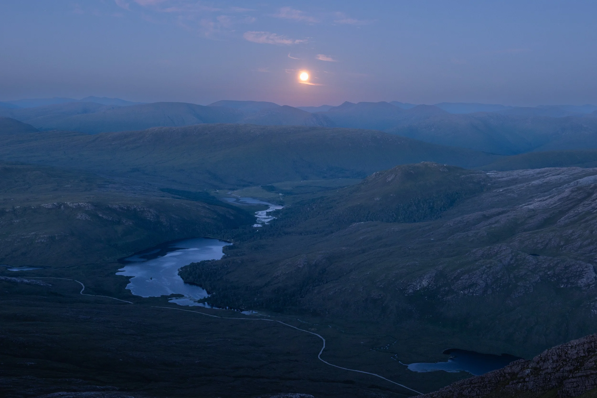
The moon rises above Loch Clair in Glen Torridon, Scotland, as seen from the summit of Spidean Coire nan Clach

The morning sun colouring the sky pink behind Spidean Coire nan Clach summit ridge

Looking east at dawn from the summit of Spidean Coire nan Clach, including the Black Carls

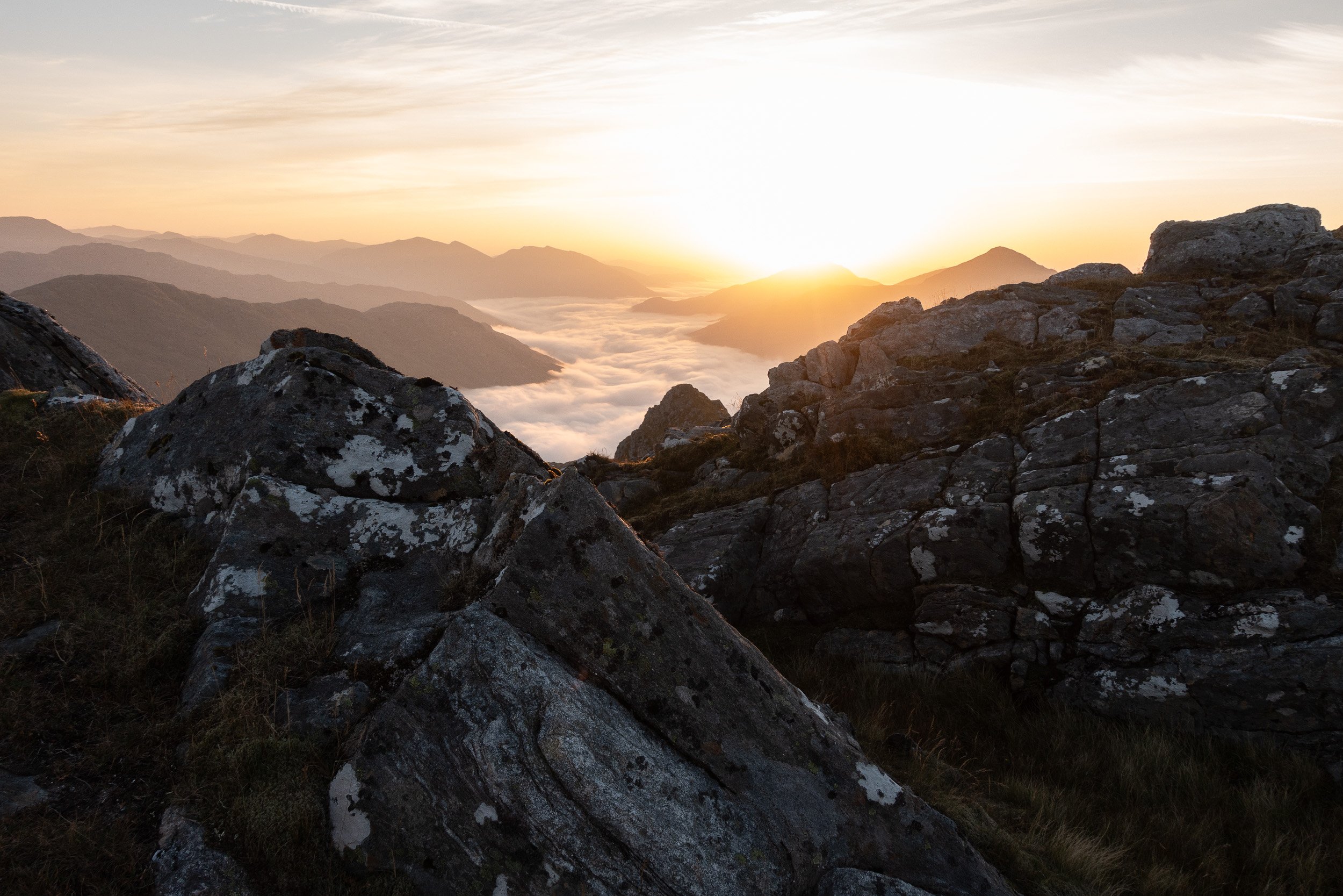
Dawn breaking behind Stob Coire nan Clach in Beinn Eighe National Nature Reserve

Dawn light on the rocky ridge between Spidean Coire nan Clach on Beinn Eighe towards Coinneach Mhor and Ruadh-stac Mòr

Dawn light on the Letterewe and Fisherfield hills behind Spidean Coire nan Clach

The morning sun rising over the shoulder of Spidean Coire nan Clach, with the rocky ridge out to the Black Carls

Spidean Coire Nan Clach at sunrise looking north-east towards Sgurr Ban and the Black Carls

Looking west from the summit of Spidean Coire nan Clach on Beinn Eighe towards Liathach and Ruadh-stac Mòr

Looking west from the rocky ridge of Spidean Coire nan Clach towards Liathach and Ruadh-stac Mòr

Wild camping and photography - Beinn an Aodainn
Sunrise from a wild camp on the summit of Beinn an Aodainn in the Knoydart peninsula of Scotland.
Part of a Wild camping and photography series.

Beinn an Aodainn (also known as Ben Aden) is a Corbett in the North-West Highlands of Scotland. It’s located in Knoydart which is roughly 25 miles north-west of Fort William as the crow flies. A typically rugged landscape, it’s a long way from the nearest road.
Scotland’s Knoydart peninsula is commonly promoted as a ‘Last Great Wilderness’. I don’t believe this to be true (you can reach it by ferry, there’s a public house and there’s many man-made tracks and paths that aid your travel) but I do believe that another term for it - ‘The Rough Bounds’ - is highly accurate. The prevailing rocky or tussocky ground, and relentlessly steep slopes, makes for taxing hillwalking, especially with a heavy backpack (or - on two occasions where I’d initially thought I was fortunate to have blue skies - when you’re being baked under a relentless sun). Add to this a long walk from the nearest entry points to get to the foot of the peak - the shortest for Beinn an Aodainn is three hours - and you’re faced with some of the toughest hillwalking in Scotland. It’s a gold mine though for backpacking and camping.
This was my fifth time visiting Knoydart, having previously walked in from both Kinloch Hourn and Glen Shiel, taken the ferry in from Inverie and sea kayaked in along Loch Hourn. My friend had four hills left to do on his Corbett round - having completed all his Munros - and I’m slowly ticking off all my Munros. Garbh Chioch Mhor and Sgurr nan Coireachan are two of just three I’ve not done in these parts with the other being Meall Buidhe, which I’d bypassed back in 2011 due to nerve issues in my foot.
On that 2011 trip, we ticked off most of Knoydart’s Munros and Corbetts, including Beinn na Caillich, Ladhar Bheinn, Luinne Bheinn, Beinn an Aodainn and Sgurr na Ciche. On another trip I climbed Beinn Bhuidhe and on a different visit, we ascended Sgurr nan Eugallt and the Graham, Slat Bheinn, before topping out on Sgurr a'Choire-bheithe. Our plan that day was to do Beinn an Aodainn as well, negating the need for this current trip, but the length of our route, heat exhaustion, the late time of day and a plague of horse-flies all tallied up to us choosing to miss it out. The best things though, as is said, often come to those who wait.
Getting there
Our starting point for Beinn an Aodainn was near Kinloch Hourn, which is around 1h 40 mins travel from Fort William by car, or perhaps a taxi if you’re doing a through-route (see this Weekend Wonder: Ladhar Bheinn feature for more options). We walked along the shores of Loch Cuaich / Loch Quoich on a mostly boggy and very overgrown track, for approximately 3 hours, before heading first towards Lochan nam Breac and then into the corrie, following Allt Coire na Cruaiche to reach Bealach na h Eangair (following the route as described by Walk Highlands). We were on the summit of Beinn an Aodainn in just under six hours.
Camping-wise, there’s relatively few spaces I saw to put a tent on the summit of Beinn an Aodainn but we easily got two pitches and there looked to be places off to the north-west as well. I’d recommend taking a soft flask with a filter as there are numerous small lochans near the summit you can take advantage of. Otherwise (and probably also in drought conditions) you’ll need to carry all your water up the hill.
Camera equipment
Sony RX100 Mark V - I considered taking my full-frame camera but we had three Munros to do after this summit so I decided that the lighter the equipment I carried the better. (View more of my Sony RX100 images here).

The walk in along Loch Cuaich

Looking back to Loch Cuaich from the ascent of Beinn an Aodainn. Our starting point was the far shoreline, out of sight to the left.
Bealach na h Eangair, with Loch Nevis visible between Sgurr na Ciche and Beinn an Aodainn (Click to view larger)

Loch Nevis from the summit of Beinn an Aodainn

Rock towers near the summit of Beinn an Aodainn
The rising sun behind a cloud-covered Loch Cuaich from the summit of Beinn an Aodainn (Click to view larger)


Early morning clouds dispersing from the shores of Loch Cuaich

Wild camping and photography - Beinn Laoigh
Photography from a summit camp on Beinn Laoigh, a Munro in the West Highlands of Scotland.
Part of a Wild camping and photography series.

Looking over to Ben Laoigh's rocky east ridge and Coire Goathach from Ben Oss
Beinn Laoigh, commonly known as Ben Lui, is a Munro in the West Highlands of Scotland. Located c.8km from the village of Tyndrum, the peak is seen often from the A85 roadside, it’s fine horseshoe-shaped northern corrie, Coire Goathach, providing a commanding view for passing traffic, especially so in when it’s in full winter conditions.
A winter ascent of Beinn Laoigh from the east, up the classic Central Gully, had long been my plan but my only previous ascent of Beinn Laigh was in 2001, from Glen Lochy in the west due to an outbreak of Foot and Mouth Disease in the United Kingdom. I’ve not climbed Central Gully - and likely won’t as my appetite for winter climbing has waned as I’ve got older - but on this occasion it wasn’t possible as a winter climb as there was no snow of note, despite being December. What had piqued my interest was a temperature differential of greater than twelve degrees, with the forecast for Tyndrum at 232m being below freezing conditions and Beinn Laoigh’s summit (at 1130m) forecast for plus 12 degrees Celsius - a classic recipe for a cloud inversion.
Cloud inversions, or more accurately temperature inversions, I understand are relatively rare. Most common in the colder months of the year, they’re caused - in my super simple terms - when the air temperature at lower altitudes is colder than the air at higher altitudes, which causes a layer of fog to form beneath you as you climb a mountain. I’ve popped out of the fog before on a Munro to find myself above a cloud inversion, which is great, but I much prefer waking up on the summit of a peak with the clouds beneath me.
Getting there
I travelled from Edinburgh to Glasgow Queen Street by train (Scotrail) and then took an onwards connection from Glasgow Central to Tyndrum on the Fort William line. From Tyndrum, the common route to Beinn Laoigh is a long (c.9km) but straight-forward walk from Dalrigh up Glen Cononish, home of a gold mine, to the foot of Coire Goathach, which I followed for a while but, because I was ticking off Munros on my Munro round, I broke off early up the steep south-west slopes of Beinn Dubhcraig to climb Ben Oss first. Heading south-west from Ben Oss and then north-north-west up the flanks of Beinn Laoigh to its summit felt somewhat adventurous but it was mainly a lot of hard work, especially with camping and photography gear. I arrived at the summit at 4pm, just as the sun was going down, and I pitched my tent just off the summit, at a small area of grass which I imagine is the only possible place on this fine rocky mountain to put a tent.
Camera equipment
Nikon D810
Nikon 24-70mm F2.8
Lowepro Toploader AW 75


The moon rising above the waters of Glen Cononish, which eventually flow into Loch Tay

Wild camping on the summit of Beinn Laoigh

The view south from Beinn Laoigh summit towards the Arrochar Alps, as the sun sets

Ben Cruachan and Stob Daimh from the summit of Beinn Laoigh

Looking over Beinn a' Chleibh towards the Paps of Jura

A cloud inversion fills Glen Cononish beneath the east ridge of Beinn Laoigh

A cloud inversion fills Glen Cononish as seen from the rocky summit of Beinn Laoigh

The slopes of Beinn Chuirn, a Corbett above the gold mine in Glen Cononish, and beyond towards Glen Lochy

A large split rock on the summit of Beinn Laoigh gives a commanding view down a cloud-filled Glen Cononish

Descending into the clouds on the return to Tyndrum

Wild camping and photography - Màm Sodhail
Overnight on Màm Sodhail, a Munro above Glen Affric in the North-West Highlands of Scotland.
Part of a Wild camping and photography series. (View more images from this Glen Affric backpacking trip in a separate blog)

The moon rises behind the ridge leading out from Mam Sodhail to Sgùrr na Lapaich
As I’d packed for a weekend’s backpacking with a friend in November, in Glen Affric in the North-West Highlands of Scotland, I realised that I hadn’t missed the weight of a DSLR camera, especially on top of the 12kg of hillwalking and camping equipment I was planning to carry.
Throughout the summer season I’d been illustrating my outdoor activities with a light-weight Sony RX100 compact camera, photographing trail running routes in Edinburgh’s Pentland Hills plus some attempts I’d made on Tranter's round in Glen Nevis. It was a change therefore to be carrying a professional DSLR up and down hills again. The image quality and usability of my work models - a Nikon D810 in this case - is streets ahead compared to my Sony and I was banking on the photographic opportunities a favourable high pressure forecast, squeezed in between two periods of low, looked to offer. Old-school DSLRs and professional lenses however aren’t light and I was conscious I was adding an extra 2kg to the weight of my pack for a trip that we'd mapped out as 40km distance over two days, with 2100m ascent.
The weight penalty of professional camera equipment I felt was worth it on this occasion. Glen Affric is often referred to as one of Scotland’s most scenic glens and the Walk Highlands website describes two of the peaks we'd chosen for our backpacking trip - Càrn Eige and Màm Sodhail - as the "highest mountains north of the Great Glen and spectacular viewpoints". Both mountains are Munros, two of the 282 Scottish peaks over 3,000ft high that are listed in Hugh Munro’s tables, with Mam Sodhail, or the ‘Hill of the Barns’, being the smaller of the two by just two metres, standing 1181m tall.
We’d started our trip the previous day at a car park in Glen Affric, camping c.6km from the car on what I imagined were the only two pieces of dry ground that day in Gleann nam Fiadh. The terrain was drier higher up and, in the morning, as we admired the golden colours of the landscape - it was abnormally autumnal weather for November - we ascended Coire Mhic Fhearchair and headed for Sròn Garbh and the rocky ridge that leads from Stob Coire Dhomhnuill onto Càrn Eige. From there we summited Beinn Fhionnlaidh and retraced our steps, our plan being to continue over Màm Sodhail towards another nearby Munro, An Socach, and camp on a bealach beneath that peak, ascending An Socach for our fourth Munro of the trip the following morning.
I distinctly recall standing beside Màm Sodhail's huge summit cairn, pondering the views Càrn Eige and Màm Sodhail were said to offer. We couldn’t see much at all but neither of us were even remotely disappointed. Since lunchtime, a thick blanket of cloud had filled the glens beneath us, 360 degrees around. It stretched as far as our eyes could see - at least all the way to Fort William in one direction, almost 100km away. Camping above a cloud inversion is not something I’ll ever turn down and we easily made the decision to stop for the day, much earlier than planned, pitching our tents about 3.30pm as the sun started to dip towards the horizon. Settling in to take in the glorious view we had above the clouds, I thought of the many times I had walked and camped in poor weather. These were special moments indeed. (If it’s any consolation, on exiting our tents the following morning, we found ourselves to be completely within these clouds, with absolutely no views at all).
Getting there
For Glen Affric, head south out of Inverness on the A82 toward Drumnadrochit. Take the A831 towards Cannich and then continue south-west along Glen Affric to reach the car park at grid reference NH215242. For Càrn Eige and Màm Sodhail, take the track through the woods which leads you first west and then north into Gleann nam Fiadh. Alternatively, drive further up Glen Affric and park at GR N201234, follow the track along the northern side of Loch Affric and ascend via Coire Leachavie.
Camera equipment
Nikon D810
Nikon 24-70mm F2.8
Lowepro Toploader AW 75

Mam Sodhail's large summit cairn

Wild camping on the summit of Màm Sodhail

Sgurr na Lapaich peaks out above the clouds

Clouds lap over the bealach between Màm Sodhail and Càrn Eige

Gleann nam Fiadh filled with clouds between Carn Eige and Sgurr na Lapaich

Looking over the Glen Shiel peaks towards Ben Nevis on the far horizon

Wild camping and photography - Bidean nam Bian
Mountain landscape photography from the summit of Bidean nam Bian, a Munro in the West Highlands of Scotland.
Part of a Wild camping and photography series.

My Hilleberg Akto tent pitched on perfect grassy ground near the summit of Bidean nam Bian, a Munro in the West Highlands of Scotland
An obvious key attribute for an outdoor photographer is good health. A few years back, after many other solutions had failed, I’d opted for surgery to address increasingly uncomfortable nerve pain I’d been experiencing in my feet when walking or running. A skilled surgeon had recommended that he fracture and re-adjust three metatarsal bones in my right foot to give the nerves a little more space. After 16 weeks recovery, I felt my foot was strong enough to cope with an easy hill walk. Keen to take advantage of a great spell of weather in Scotland, I decided to break up my first trip back with a wild camp on the summit of Bidean nam Bian, a Munro above Glen Coe in the West Highlands of Scotland.
My recollection is, as I’d prepared my camping gear and camera equipment, I was looking forward to heading back to Glen Coe. I’ve visited the area many times before, which includes the village of Glencoe, and I’d decided to return for good reason - the landscape in such a small place is incredibly varied. Past trips include bivvying on the summit of Stob Coire nan Lochan, watching beautiful clouds that filled the glens at dawn, and a bivvy on top of Am Bodach on Aonach Eagach across the glen, where I was treated to a lovely sunrise that turned the hills purple and lit up my previous sleeping spot on Stob Coire nan Lochan. (You can see these latter images in my Glen Coe and Lochaber photo essay).
My plans for this return trip were to ascend from Glen Coe into the corrie above Loch Achtriochtan, beneath Dinnertime Buttress, and continue upwards towards the steep crags of Stob Coire nam Beith before breaking off west onto the bealach beside An t-Sron. I’d then spend time creating mountain landscape before continuing up the ridge to camp for the night on the summit of Bidean nam Bian (which, at 1107m high, is the highest peak in the old county of Argyll).
The internet is the obvious valuable resource for a mountain landscape photographer. With many useful tools such as Google Maps, Google Images and the Sunseeker app (or alternatives such as Photographer’s Empheris), you can plan out in detail exactly which locations should be worth going to and when, with the huge advantage of knowing in advance where the light will fall. You can research up-front in the comfort of your home or office and, on the day, it's hopefully simply a case of being blessed with good weather.
On this occasion, I had the summits of both Stob Coire nam Beith and Bidean nam Bian all to myself. For a short while, there was two people on the summit of Stob Coire nan Lochan, over a kilometre away (I think they’d scrambled up a route on Dinnertime Buttress), but when they'd gone it was just me and an uninterrupted 360-degree view I had of many of the beautiful glens, lochs and mountains that make up the Glen Coe and Lochaber region in Scotland, plus nearby Glen Etive and more. I'd read there was good ground for camping just to the west of Bidean's rocky summit and this proved correct - there's a lovely lawn-like area with minimal rocks in the ground that is an ideal place to pitch a tent. (You could also take a bivvy bag but I’d opted this time for the additional protection a tent provides due to my anticipation that I’d be blighted by that scourge of Scottish summer camping, the Scottish midge (which thankfully never materialised). I did though manage to lose a bag of semi-frozen grapes to a crow, which I'd been HUGELY looking forward to because it was very warm. There was almost a murder.
By midnight, I’d stopped taking photographs and was settled down in my sleeping bag, my alarm set for 3.00am (plus, as a precaution, 3.20am, 3.30am and 3.45am). Sunrise on this day was at 4.30am but it never really got dark and at 2.30am I popped my head out my tent to find it relatively light and with a lot of colour still in the sky. I decided I’d just get up and I was glad I did, as I spent a very special few hours in beautiful silence picking out landscapes on the horizon as the sun slowly came up, which allowed me to capture a range of mountain landscape images that I was really happy with and was Iooking forward to sharing with clients.
As for my foot? Unfortunately, it wasn’t strong enough. An innocuous slip on the way down caused me to put all my weight through it and it didn’t cope well at all. After a painful and lengthy descent (and a recommended x-ray from the hospital - which thankfully showed I hadn't re-broken it and it was likely tissue damage) I was back on the mend, although highly mindful of a friend’s advice, which is to be careful and to 'remember, you need your feet forever”.
Camera equipment
Nikon D4S (My Nikon D810 was in for a service)
Nikon 24mm f1.4
Nikon 70-200mm f2.8
Calumet wireless transmitter/receiver
Manfrotto Carbon Fibre tripod
Filters (Circulariser polariser / Graduated ND filter)
F-Stop Satori camera backpack
(The above forms part of my photography equipment list)

View from the summit of Bidean nam Bian over the ridges of Bheinn Fhada and Buachaille Etive Beag, plus the summit of Buachaille Etive Mor, towards Schiehallion

Orange-tinged clouds at dusk looking north from the summit of Bidean nam Bian. In view is Aonach Eagach, Sgurr a’Mhaim and Am Bodach in the Mamores, plus the big 4,000+ft peaks above Glen Nevis - Ben Nevis, Carn Mor Dearg, Aonach Mor and Aonach Beag.

Rocks have been balanced near the summit cairn on Bidean nam Bian, one of which points towards Ben Nevis, the UK’s highest peak.

The small rocky cairn adorning the summit of Bidean nam Bian

The view down to Ballachulish bridge from the summit of Stob Coire nam Beith, as Loch Leven spills out into Loch Linnhe in the West Highlands of Scotland

Looking over Stob Dearg summit on Buachaille Etive Mor towards Schiehallion

Looking over Aonach Eagach to Na Gruagaichean and Binnein Mor, two Munros in the Mamores, from the summit of Bidean nam Bian

Afternoon light illustrates two hikers standing on top of the scree-covered summit of Stob Coire nan Lochan

The panoramic view north from the summit of Bidean nam Bian, looking over Stob Coire nan Lochan, Aonach Eagach plus most of the Mamores to Ben Nevis (the UK's highest peak). Carn Dearg, Aonach Mor, Aonach Beag, the Grey Corries, Stob Coire Easain and Stob a' Choire Mheadhoin are also in view.