Blog

Wild camping and photography - Spidean Coire nan Clach (Beinn Eighe)
Sunset and sunrise from the summit of Spidean Coire nan Clach, a Munro on Beinn Eighe in the North-West Highlands of Scotland
Part of a Wild camping and photography series.
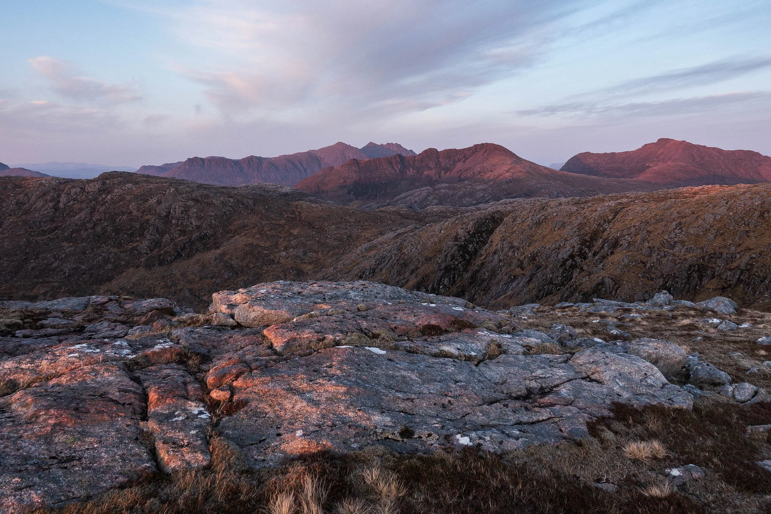
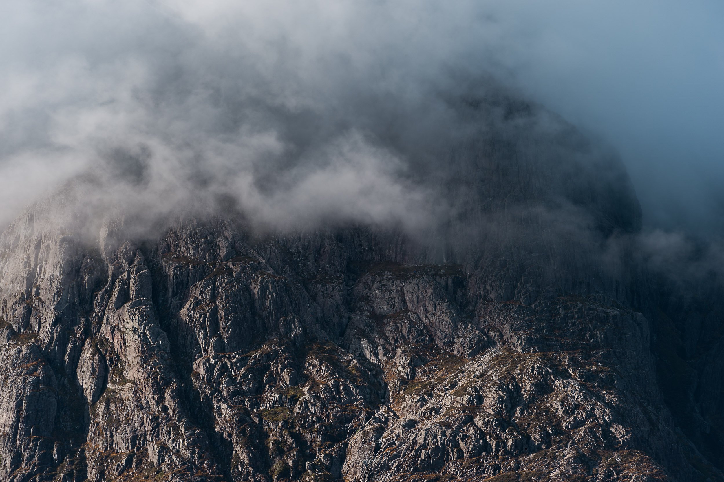
Dawn light on the rocky ridge between Spidean Coire nan Clach on Beinn Eighe towards Coinneach Mhor and Ruadh-stac Mòr
The Beinn Eighe massif in Torridon was designated as Britain's first National Nature Reserve in 1951. The NNR website details how the massif 'embraces a vast area of 48 square kilometres' between Loch Maree and Glen Torridon, 'stretching from loch-side to mountain top', with a 'huge cluster of rugged peaks, ridges and scree-covered slopes' in between. Two of these peaks are Munros, or Scottish peaks over 3,000ft / 914.4m meters high. To the west is Ruadh-stac Mòr, above the fantastic Loch Coire Mhic Fearchair, and to the east, at the end of a c2.5km long ridge that includes the Black Carls, is the rocky Spidean Coire nan Clach.
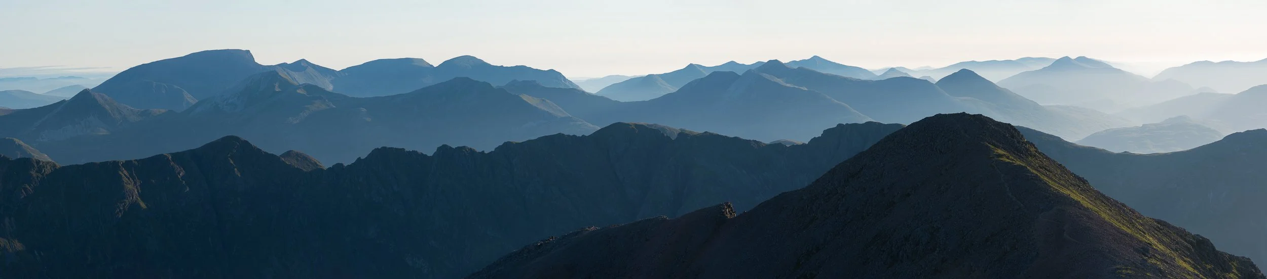
This was my thirteenth (you’ll find out fourteenth) ascent of the Munro, Spidean Coire nan Clach, on Beinn Eighe above Glen Torridon. I used to photograph the Celtman Extreme Triathlon and I always made a point of going to the summit - it’s a fun, easy scramble - but this was the first time I’d chosen to spend the night. My objective was to capture a panoramic photograph of the ridge between this and the second Munro Ruadh-stac Mòr, to create a personal memory which would appeal to any Celtman competitors who have ran the ridge during the race on their way to a coveted Blue T-shirt.
After a hot and muggy ascent, I was blessed with a cool breeze which increased to c.40mph through the night and saw me cooried in beside the trig point at 972/977m with a warm jacket on but no sleeping bag. Sunset and sunrise was nice but it wasn't the best it could be for photography but the joy of being alone on top of a Munro never stops. A midnight clamber along the rocky ridge to Spidean Coire nan Clach’s summit was fun - if regrettably too short - as is the continuation of said ridge out to the Black Carls (which I've done before, on an east to west traverse of Beinn Eighe from Kinlochewe - and would highly recommend).
I’d have loved to have stayed out but unfortunately work needs pressed and I was home for 9am. Regrettably this was when I discovered that I had dropped a memory card at the car park in Glen Torridon when I opened my camera bag to retrieve my car keys, and I had lost all my sunset images from the evening before. A big mistake which was both very annoying and highly embarrassing - definitely an amateur mistake. My immediate thought was to go back and get it but it was a 90-minute drive and I’d had minimal sleep the evening before, and I was very tired. For safety reasons I chose instead to put out a message on the Walk Highlands and UK Hillwalking websites and trust that it might turn up. This proved to be no avail - my bad - and, after a few weeks of stewing about it, I decided I was just going to have to go back and take some new photos. No great hardship for me other than the 850m climb - and I struck lucky with even better light - but it was a large lesson learned as regards to backing up cards on location, plus having a label on my cards which has my contact details on it.
Getting there
There’s no rail service to Glen Torridon, the closest being Garve, which is reached from Inverness, but it is possible to get a bus from Inverness to Kinlochewe. Both options however leave you a long way from the starting point, which is the car park with a small copse of trees at grid reference NR977579. I’d suggest therefore it’s best simply to drive, sharing the transport with others if possible.
The usual hillwalking route on Beinn Eighe is to follow the ridge west towards Coinneach Mhor and then Ruadh-stac Mòr before descending the steep (and these days very bare at the top) scree gully into the fantastic Coire Mhic Fhearchair. You’ll find the details on Walkhighlands.co.uk, with the Harveys Torridon map I’d propose best for navigation or the British Mountaineering Council’s Fisherfield and Torridon version. On both occasions here though, due to ongoing recovery from a long-term injury, I chose simply to ascend Spidean Coire nan Clach on its own and I bivvied overnight right next to the cairn marked at Pt 972 (977m) on the map. This has just enough space for a sleeping mat for one. (If you’re interested in taking similar photos, my recommendation would be a RidgeRest rather than an inflatable mat as the ground is quite rocky).
Camera equipment
Nikon D810
Nikon 24-70mm F2.8
Lee Filters, remote triggers, etc.

Strong afternoon sunshine lights up the rocky summit of Spidean Coire Nan Clach on Beinn Eighe

The view over Allt Coire Ruadh-staca and Glen Grudie as the sun sets behind Poolewe

The sun setting behind the summit of Ruadh-stac Mòr, a Munro on Beinn Eighe

The sun setting behind Loch Ewe from the summit of Spidean Coire nan Clach
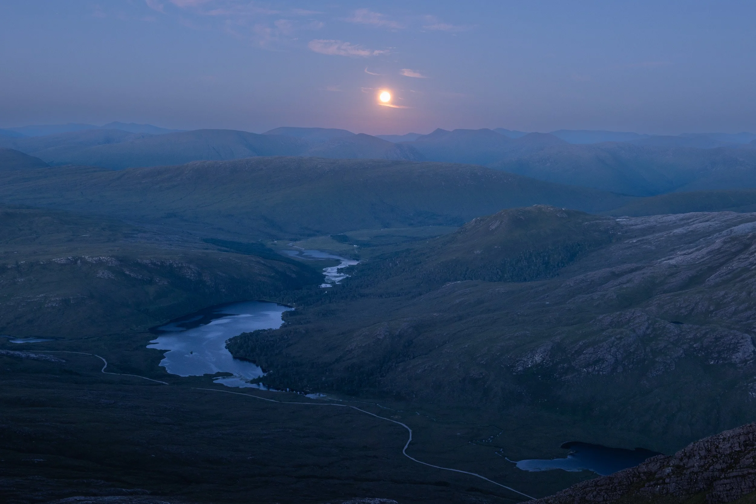
The moon rises above Loch Clair in Glen Torridon, Scotland, as seen from the summit of Spidean Coire nan Clach

The morning sun colouring the sky pink behind Spidean Coire nan Clach summit ridge

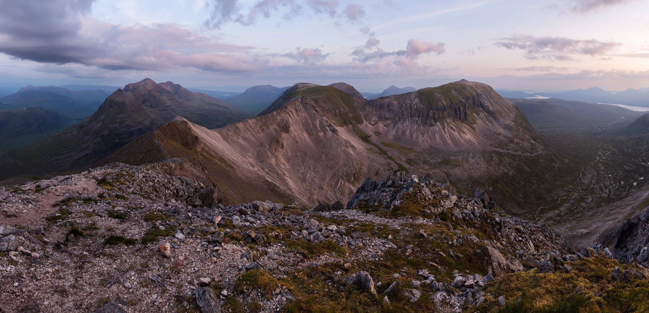
Looking east at dawn from the summit of Spidean Coire nan Clach, including the Black Carls

Dawn breaking behind Stob Coire nan Clach in Beinn Eighe National Nature Reserve

The morning sun rising over the shoulder of Spidean Coire nan Clach, with the rocky ridge out to the Black Carls

Dawn light on the Letterewe and Fisherfield hills behind Spidean Coire nan Clach

Dawn light on the rocky ridge between Spidean Coire nan Clach on Beinn Eighe towards Coinneach Mhor and Ruadh-stac Mòr
The day breaks along the rocky ridge of Spidean Coire nan Clach towards Liathach and Ruadh-stac Mòr
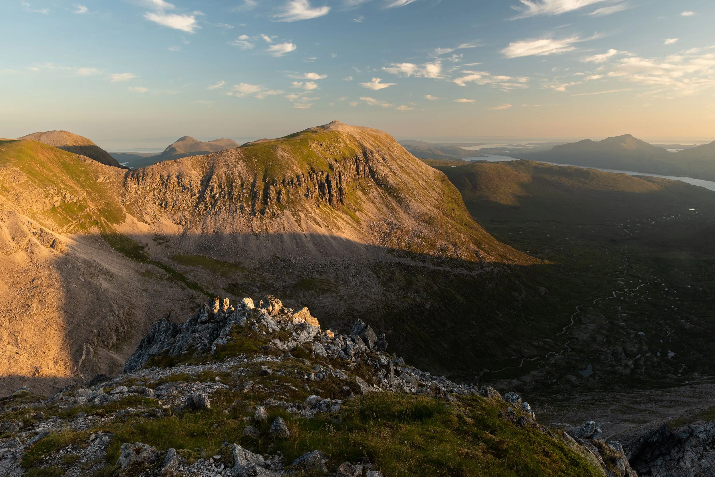
Early morning light on Ruadh-stac Mòr

Looking west from the summit of Spidean Coire nan Clach on Beinn Eighe towards Liathach and Ruadh-stac Mòr

Letterewe Corbetts - On the edge of Fisherfield
Joining a friend on the Letterewe estate, on his journey to complete the Corbetts.

From left to right: Beinn Lair, Beinn Airigh Charr, Beinn Tharsuinn Chaol, Beinn a' Chaisgein Mor and A’Mhaighdean on the Letterewe estate in the North-West Highlands of Scotland
Letterewe and Fisherfield are two parts of Scotland I’d always understood to be owned by estates of the same name but as I researched this post I learnt they’re not. Rather, the area (which, combined, is managed as a large and, for Scotland, somewhat remote, deer forest) is owned by different estates including Letterewe plus Dundonell, Eilean Darach, Little Gruinard and Larachantivore. (Source: West Ross Deer management Group). The largest land-owner, I believe, with 43,000 acres of land, is the Letterewe estate, which shares on its website that is ‘protected from insensitive development and has no surfaced roads’.
There’s two common routes into Fisherfield / Letterewe, an area often labelled - I’d suggest erroneously - as ‘The Great Wilderness’ (although the ‘great’ part is definitely true). Corrie Hallie is one starting point on the A832 in the North-East for Fisherfield forest, with Poolewe for Letterewe in the North-West. I’ve also accessed Letterewe from the South-East, walking in along the north shore of Loch Maree before heading northwards over Bealach Mheinnidh towards Fionn Loch and Carnmore, plus I’ve climbed some of the the Fisherfield Munros from Incheril and the Heights of Kinlochewe. It’s also possible to access the hills from Gruinard Bay in the north. All of these routes involve long walk-ins, initially on tracks, then stalker’s paths that lead upwards onto grassy and rocky hillsides forming a landscape that hosts six of Scotland’s Munros (Slioch, Sgurr Ban, Mullach Coire Mhic Fhearchair, Beinn Tarsuinn, A’Mhaighdean and Ruadh Stac Mor), six Corbetts (Beinn a' Chlaidheimh, Beinn Dearg Mòr, Beinn Dearg Bheag, Beinn Lair, Beinn Airigh Charr and Beinn a' Chaisgein Mor) and two Grahams, which I’ll mention below.
The purpose of our visit to Letterewe was for a friend to finish all his Corbetts (which are 222 Scottish hills between 2,500 feet and 3,000 feet high). Joining him was myself, plus another friend who has completed all his Munros, Corbetts and Grahams (climbing his last one of each in 2024 over one weekend, which I’d propose is somewhat remarkable). I’m lacking behind both with only 254/282 Munros completed, and a paltry 77 Corbetts.
Our mini expedition started mid-morning on the shores of Loch Ewe, at Poolewe, near Gairloch. It was still early enough in the season to be cold in the shade - especially at night-time - but a stable, high-pressure weather window had brought sunshine and blessed us with perfect conditions for backpacking, enough so that I chose a bivvy bag over a tent, happy there was no risk of midges and a manageable risk of ticks.
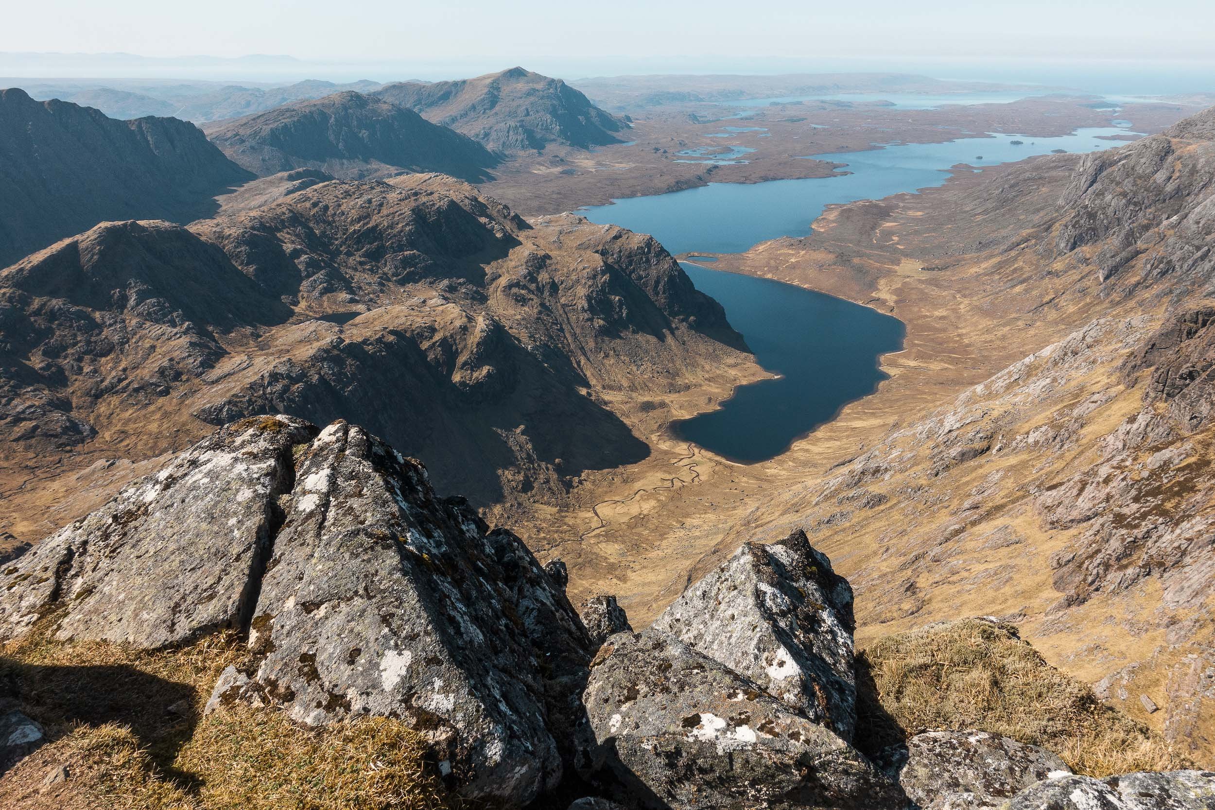
We followed a great single-track path to start, passing Kernsary farm to reach Carnmore lodge and bothy before we double-backed on ourselves and climbed our first hill, the Graham, Beinn a' Chaisgein Beag. We’d walked 25km from our car. A boat or pack-raft would have been handy for crossing Fionn Loch (translation: the white loch) which the estate shares is full of brown trout. Just after 8.30pm, we stopped for the night on the bealach to the north of Beinn a' Chaisgein Mor (Grid Reference: NG983806). There were two small lochans nearby, one of which would have provided us with water, if we’d used a good filter, but we’d chosen to carry our liquid up.
The following morning, after a leisurely start, we climbed Beinn a' Chaisgein Mor, the rocky summit providing us with fine views of all the remaining hills we planned to ascend on our two-night, three-day trip. The Corbett count for my friend was now 220/222, so just two to go. Before then, we’d chosen an ascent of the north-west ridge of the Munro, A’Mhaighdean, which I’m recalling none of us had done this before but we’d all highly recommend it. There’s nothing difficult (although we did join further up) but there’s some mild clambering through crags with two squat, rocky pinnacles near the top that need some consideration to bypass, unless you’re carrying climbing equipment to descend / ascend them direct. (Tip - At the first bluff, if you’re facing towards the summit, reverse back slightly and descend left into a steep gully and take the first right). The summit of A’Mhaighdean is easily reached thereafter. And it has amazing views, often described as the best in Scotland.
A key goal of our trip was to visit another part of Letterewe that we hadn’t been to, which was Beinn Tharsuinn Chaol, a rocky ridge between the waters of Gorm Loch Mor and the remarkable cliffs of Beinn Lair. In the end, given the time of day, we traversed mostly underneath this ridge line on the south side, descending early to reach Bealach a' Chùirn and a welcome stalker’s path which led us neatly around to Bealach Mheinnidh, which we’d chosen for our second camp of the trip. After getting ourselves ready for the evening, we climbed Beinn Lair in really nice evening light and my friend’s Corbett count was now 221/222. Just one to go!
Our journey to our friend’s final Corbett, and the last hill of our trip, was characterised by steep ascents followed by even steeper descents, which thankfully were softened by fine views. We climbed 280m to the summit of the Graham, Meall Mheinnidh, and then made a punishing 460m descent and 540m ascent up to the summit of Beinn Airigh Charr. Corbett 222/222 was celebrated in style with a half-bottle of champagne before we reluctantly started our long walk back to Poolewe. Our spirits remained high throughout, as the view over Loch Maree towards Torridon and the Isle of Skye as we descended was amazing, as was the landscape looking out towards Poolewe.
Camera equipment
Apple iPhone


Lenticular clouds in Scotland
Lenticular clouds behind the Munro, Slioch, in the North-West Highlands of Scotland.

Lenticular clouds over the Munro, Slioch, in the North-West Highlands of Scotland
Lenticular clouds (Latin name Atocumulus Lenticularis, or ‘like a lens’) are ‘lens-shaped orographic wave clouds forming when the air is stable and winds blow across hills and mountains from the same or similar direction at different heights through the troposphere’. (Source: UK Meteorological Office). Orographic means ‘relating to mountains’, which is likely why I’ve always found lenticular clouds highly attractive, their dramatic shapes filling the sky and providing a fine backdrop for mountain landscape photography.
At their most magnificent, lenticular clouds bring up comparisons with alien life forms and UFOs. An excellent indicator of strong jet-stream winds at altitude, they are the result of air currents that rise up over mountainous regions and cool and condense into water droplets. As the air descends, it warms and the water droplets vapourise and disappear. At its peak however, any air just above the dew point forms into clouds that remain still above the wind - picture a standing wave over a submerged rock - and they don’t move, no matter how strong the wind is. Such clouds I understand are generally a good indicator of an incoming bout of bad weather.
I first encountered great saucer-shaped clouds in the early 2000s when I was in Patagonia, trekking around Cerro Fitz Roy and traversing a section of the Southern Patagonia Ice Cap, plus later, when researching a travel guidebook to Los Glaciares National Park in Argentina. I wasn’t focused on photography back then - there’s not any lenticular clouds in my landscape portfolio at present - but I do have a great example I feel I can share, which is the cover image for US photographer Linde Waidhofer’s large-format coffee-table book, ‘Unknown Patagonia’, which has beautiful images from Chilean Patagonia. You can view Linde’s image and purchase the book at her website - www.westerneye.com.
It’s been very rare for me to see lenticular clouds in person, either in Patagonia or Scotland, and I’ve never had the opportunity to properly photograph them. This is still the case as the images below were captured in what I’d term ‘run and gun’ style from the road-side beneath the Munro, Slioch (‘the Spear’) and further east as we returned from a backpacking trip in Letterewe in the North-West Highlands of Scotland. I’m proposing however that they illustrate exceptional enough conditions for Scotland to warrant sharing.
Camera equipment


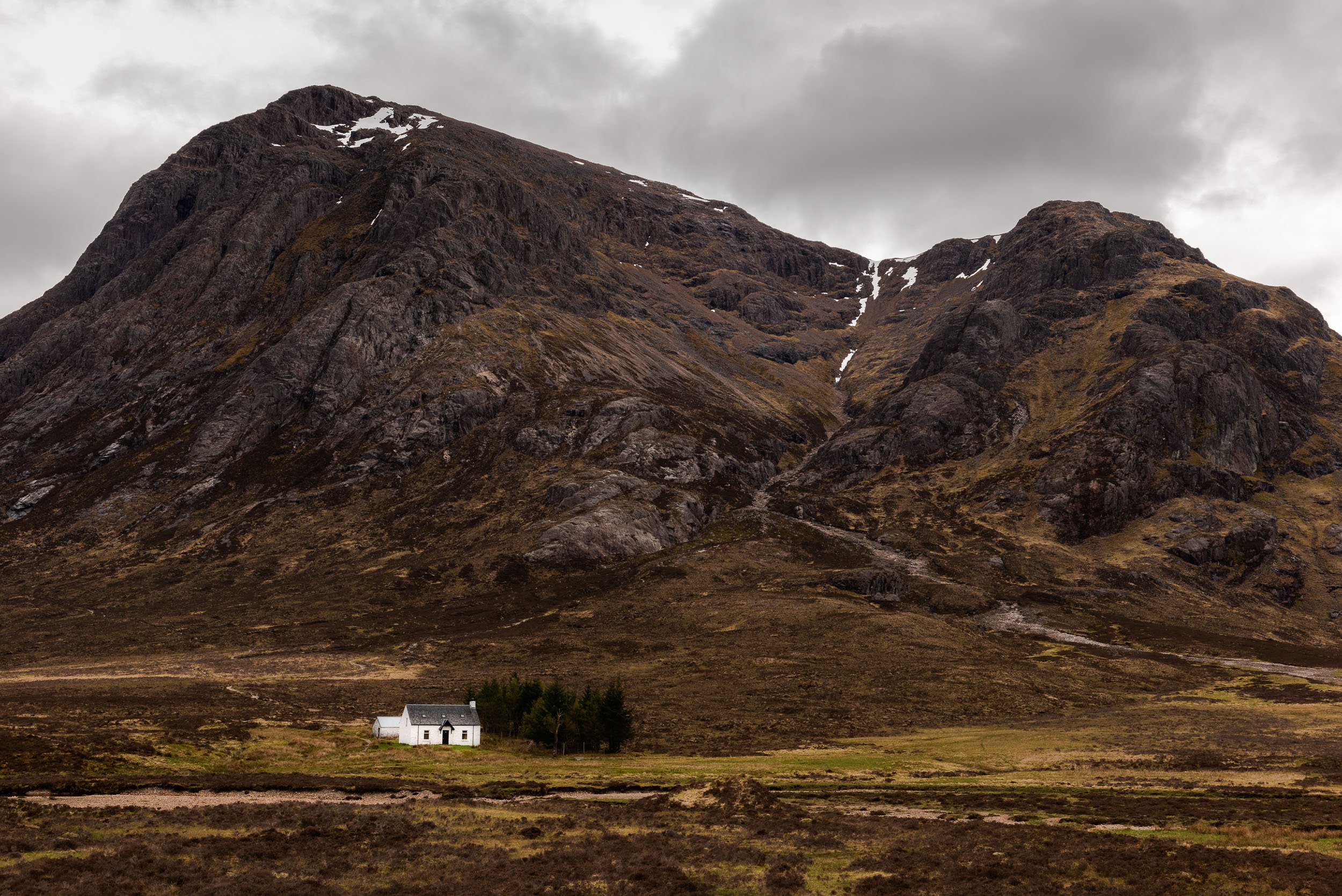
Buachaille Etive Mòr (The Great Herdsman of the Etive)
Photographs of the popular Scottish Munro, Buachaille Etive Mòr.
Buachaille Etive Mòr is a Munro, one of Scotland’s 282 hills over 3,000ft / 914.4m high. A common location for mountain landscape photographers is to position yourself on the lower slopes of Beinn a’Chrulaiste, a Corbett (a hill in Scotland over 2,500ft high), which has multiple options for wild camping and offers outstanding views of its more photogenic neighbour.
Although the slopes of Beinn a’Chrulaiste are by far not an original location for photographing Buachaille Etive Mòr (I’d imagine it’s the third most common view of the hill by photographers after the waterfall on the River Coupall and Blackrock Cottage), I was keen to see if I could capture the view without the A82 road or the river in view.
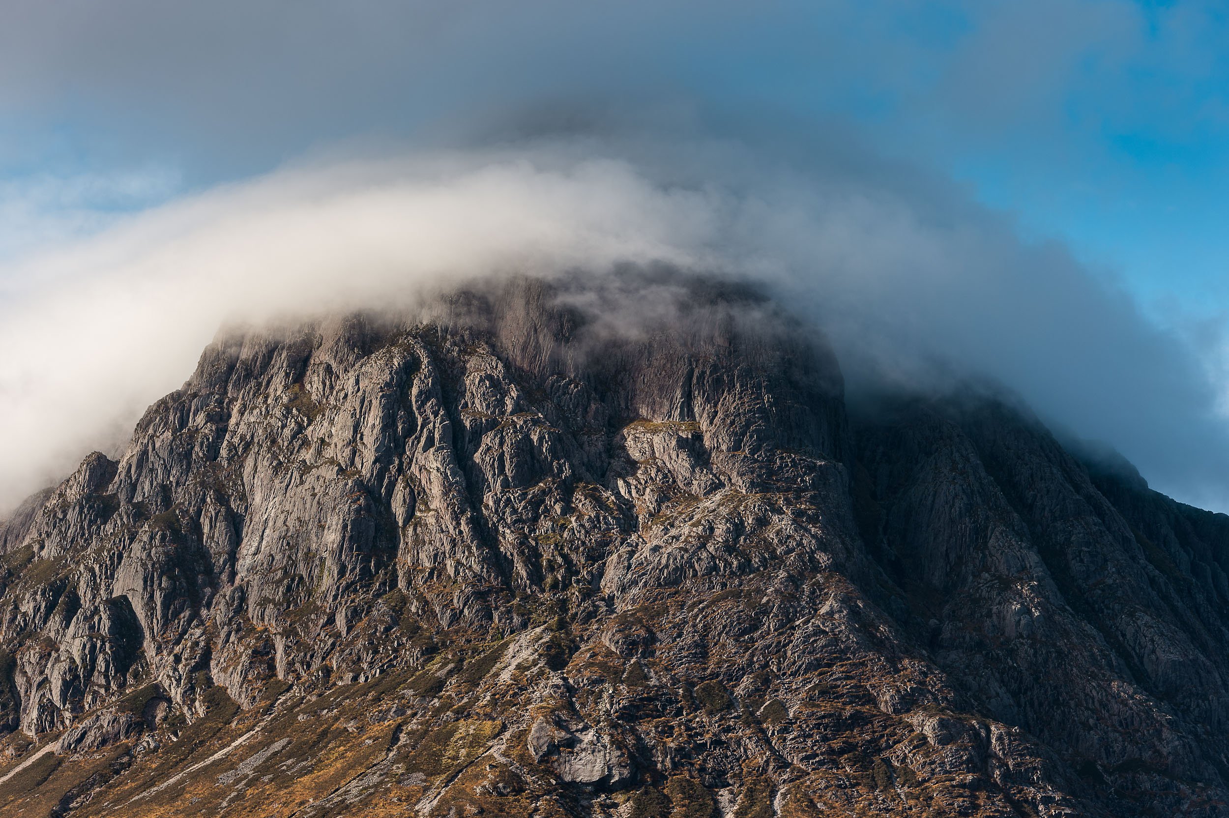
Buachaille Etive Mòr is a very popular hill with both hillwalkers and climbers. The most common ascent for walkers is via Coire Na Tulaich, a rocky amphitheatre on the northern slopes of the mountain (on the right in the photographs I’ve taken here). The corrie has a steep head wall and has been the scene of several avalanches over the years, sometimes fatal. The east and south-east faces of Buachaille Etive Mòr are a myriad of rocky ridges, gullies and steep buttresses which are popular with climbers and scramblers. An obvious waterslide slab, lit up by the sun in the fifth image below, is the starting point for Curved Ridge, a technical scramble (or low grade rock climb) I’ve enjoyed immensely in the past. It winds its way up the mountain just behind the left skyline before coming out at the notch beneath the top of the prominent Crowberry Tower. Other scrambles in view include North Buttress, Broad Buttress, Lagangarbh Buttress and the Northeast Ridge of Creag Coire na Tulaich, all to the left of Coire na Tulaich.


Mountain landscapes - Lochaber, Scotland
Mountain landscape photography showcasing the summits and ridges in the Glen Coe, Glen Etive, and Glen Nevis regions of Lochaber in the North-West Highlands of Scotland.
Lochaber is a region in the West Highlands of Scotland that is home to many of Scotland’s finest Munros, including the UK’s highest peak, Ben Nevis, its mighty neighbours (the 4,000ft+ peaks of Carn Mor Dearg, Aonach Mor and Aonach Beag and the Great Corries) and the slightly lower but no less aesthetically-pleasing (and backpacker’s delight) Mamores. Further south, the interest for walkers and climbers continues as the steep-sided hillsides and ridges continue above the glacier-gouged glens of Glen Coe and Glen Etive, home to more classic Munros such as Meall Dearg and Sgòrr nam Fiannaidh (challengingly located at either end of Aonach Eagach, perhaps the UK mainland’s trickiest mountain ridge), the huge bulk of the Bidean nam Bian massif, plus Ben Starav, a not quite as big but still a no less-fine Munro that is guarded by what I imagine to be one of the most well-loved Munros of all, Buachaille Etive Mor, aka the ‘Big Herdsman of the Etive’. What follows is a selection of images showcasing the mountain views across the landscape of Lochaber in Scotland, many taken from the summit of just one Munro, Bidean nam Bian, and its satellite peaks, Stob Coire nan Lochan and Stob Coire nam Beith.


Mountain landscapes - Chamonix Mont-Blanc
A selection of images of the mountains around Chamonix Mont-Blanc in the French Alps.
Chamonix is a busy mountain town nestled beneath two ridges of high alpine peaks in France, including Mont Blanc, Aiguilles du Dru (Les Drus), Dent du Géant and Aiguille Chardonnet. A mecca for mountain sports such as climbing and mountaineering, trekking and paragliding, it is popular also with visitors seeking out the spectacular views. I’ve been blessed with glorious sunshine when I’ve visited Chamonix, either working - on a trail or mountain running photo shoot - or spending more leisurely time with my wife trekking between alpine refuges and rewarding ourselves with fresh blackberry and apple tart, washed down with copious amounts of tea and coffee. Whatever the purpose, Chamonix is a classic location to visit in the French Alps - a great place to spend time and enjoy the experience and the views amongst the mountains.


