
Wild camping and photography - Spidean Coire nan Clach (Beinn Eighe)
Part of a Wild camping and photography series.
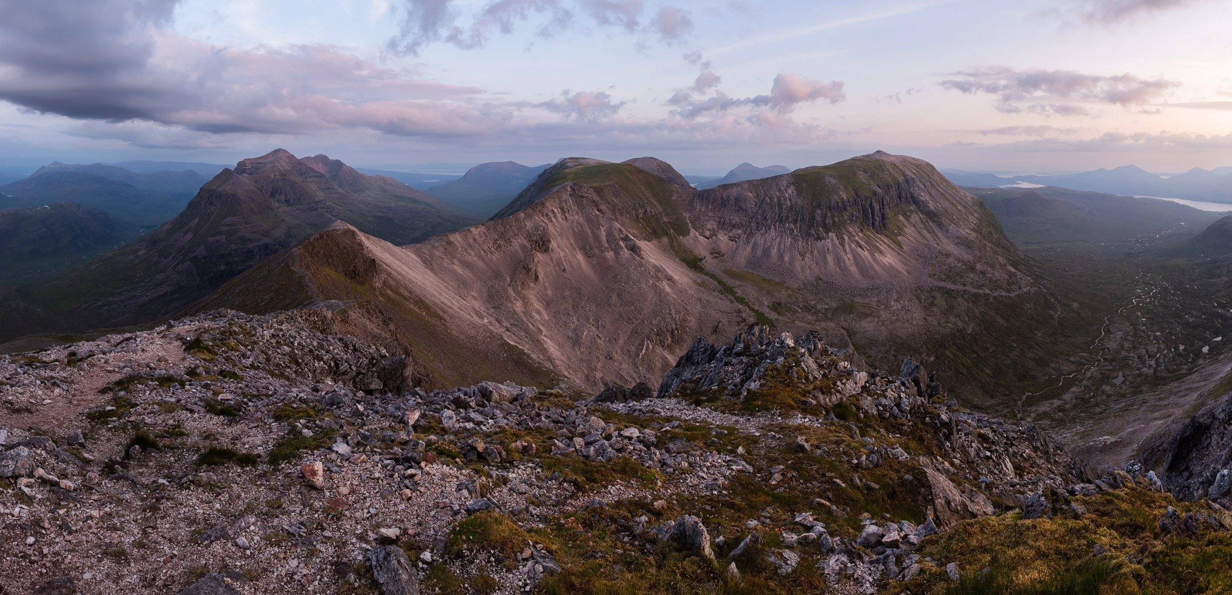
Dawn light on the rocky ridge between Spidean Coire nan Clach on Beinn Eighe towards Coinneach Mhor and Ruadh-stac Mòr
The Beinn Eighe massif in Torridon was designated as Britain's first National Nature Reserve in 1951. The NNR website details how the massif 'embraces a vast area of 48 square kilometres' between Loch Maree and Glen Torridon, 'stretching from loch-side to mountain top', with a 'huge cluster of rugged peaks, ridges and scree-covered slopes' in between. Two of these peaks are Munros, or Scottish peaks over 3,000ft / 914.4m meters high. To the west is Ruadh-stac Mòr, above the fantastic Loch Coire Mhic Fearchair, and to the east, at the end of a c2.5km long ridge that includes the Black Carls, is the rocky Spidean Coire nan Clach.
This was my thirteenth (you’ll find out fourteenth) ascent of the Munro, Spidean Coire nan Clach, on Beinn Eighe above Glen Torridon. I used to photograph the Celtman Extreme Triathlon and I always made a point of going to the summit - it’s a fun, easy scramble - but this was the first time I’d chosen to spend the night. My objective was to capture a panoramic photograph of the ridge between this and the second Munro Ruadh-stac Mòr, to create a personal memory which would appeal to any Celtman competitors who have ran the ridge during the race on their way to a coveted Blue T-shirt.
After a hot and muggy ascent, I was blessed with a cool breeze which increased to c.40mph through the night and saw me cooried in beside the trig point at 972/977m with a warm jacket on but no sleeping bag. Sunset and sunrise was nice but it wasn't the best it could be for photography but the joy of being alone on top of a Munro never stops. A midnight clamber along the rocky ridge to Spidean Coire nan Clach’s summit was fun - if regrettably too short - as is the continuation of said ridge out to the Black Carls (which I've done before, on an east to west traverse of Beinn Eighe from Kinlochewe - and would highly recommend).
I’d have loved to have stayed out but unfortunately work needs pressed and I was home for 9am. Regrettably this was when I discovered that I had dropped a memory card at the car park in Glen Torridon when I opened my camera bag to retrieve my car keys, and I had lost all my sunset images from the evening before. A big mistake which was both very annoying and highly embarrassing - definitely an amateur mistake. My immediate thought was to go back and get it but it was a 90-minute drive and I’d had minimal sleep the evening before, and I was very tired. For safety reasons I chose instead to put out a message on the Walk Highlands and UK Hillwalking websites and trust that it might turn up. This proved to be no avail - my bad - and, after a few weeks of stewing about it, I decided I was just going to have to go back and take some new photos. No great hardship for me other than the 850m climb - and I struck lucky with even better light - but it was a large lesson learned as regards to backing up cards on location, plus having a label on my cards which has my contact details on it.
Getting there
There’s no rail service to Glen Torridon, the closest being Garve, which is reached from Inverness, but it is possible to get a bus from Inverness to Kinlochewe. Both options however leave you a long way from the starting point, which is the car park with a small copse of trees at grid reference NR977579. I’d suggest therefore it’s best simply to drive, sharing the transport with others if possible.
The usual hillwalking route on Beinn Eighe is to follow the ridge west towards Coinneach Mhor and then Ruadh-stac Mòr before descending the steep (and these days very bare at the top) scree gully into the fantastic Coire Mhic Fhearchair. You’ll find the details on Walkhighlands.co.uk, with the Harveys Torridon map I’d propose best for navigation or the British Mountaineering Council’s Fisherfield and Torridon version. On both occasions here though, due to ongoing recovery from a long-term injury, I chose simply to ascend Spidean Coire nan Clach on its own and I bivvied overnight right next to the cairn marked at Pt 972 (977m) on the map. This has just enough space for a sleeping mat for one. (If you’re interested in taking similar photos, my recommendation would be a RidgeRest rather than an inflatable mat as the ground is quite rocky).
Camera equipment
Nikon D810
Nikon 24-70mm F2.8
Lee Filters, remote triggers, etc.

Strong afternoon sunshine lights up the rocky summit of Spidean Coire Nan Clach on Beinn Eighe

The view over Allt Coire Ruadh-staca and Glen Grudie as the sun sets behind Poolewe

The sun setting behind the summit of Ruadh-stac Mòr, a Munro on Beinn Eighe

The sun setting behind Loch Ewe from the summit of Spidean Coire nan Clach
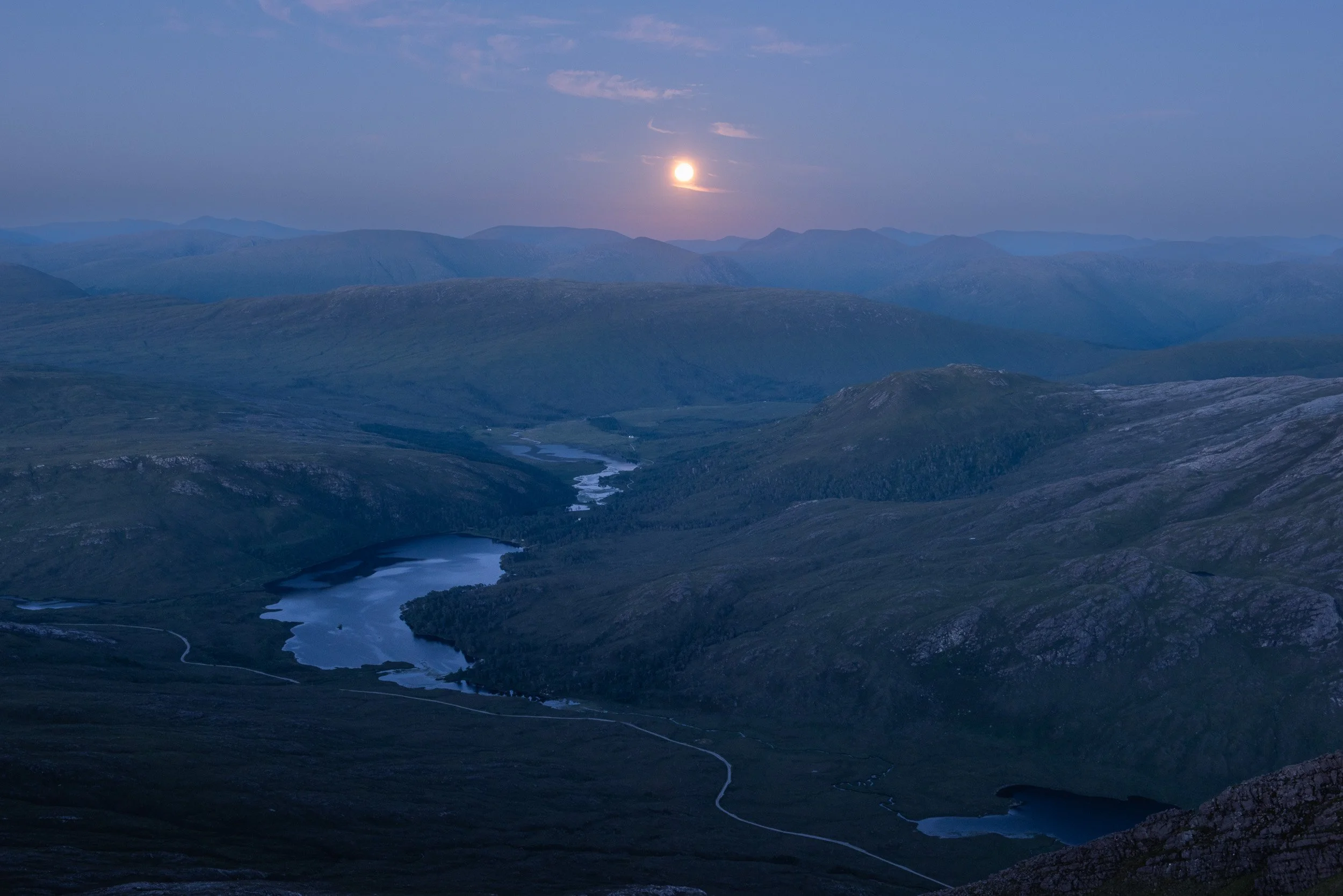
The moon rises above Loch Clair in Glen Torridon, Scotland, as seen from the summit of Spidean Coire nan Clach

The morning sun colouring the sky pink behind Spidean Coire nan Clach summit ridge

Looking east at dawn from the summit of Spidean Coire nan Clach, including the Black Carls

Dawn breaking behind Stob Coire nan Clach in Beinn Eighe National Nature Reserve

The morning sun rising over the shoulder of Spidean Coire nan Clach, with the rocky ridge out to the Black Carls

Dawn light on the Letterewe and Fisherfield hills behind Spidean Coire nan Clach

Dawn light on the rocky ridge between Spidean Coire nan Clach on Beinn Eighe towards Coinneach Mhor and Ruadh-stac Mòr
The day breaks along the rocky ridge of Spidean Coire nan Clach towards Liathach and Ruadh-stac Mòr
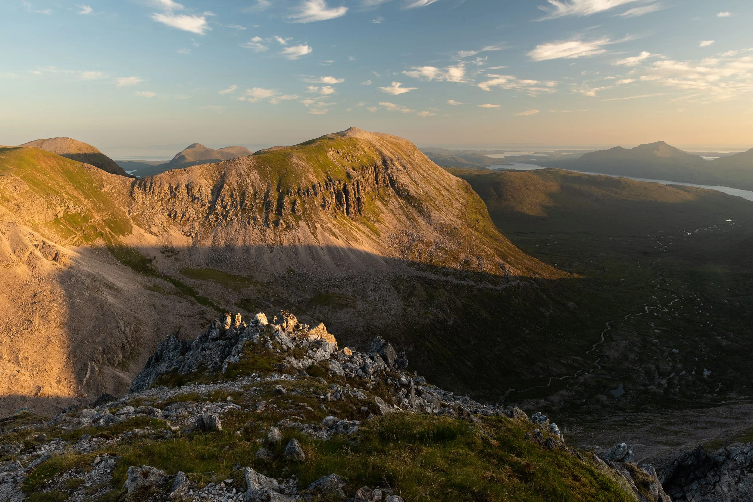
Early morning light on Ruadh-stac Mòr

Looking west from the summit of Spidean Coire nan Clach on Beinn Eighe towards Liathach and Ruadh-stac Mòr